A new smartphone app, due out this fall, will be able to provide a virtual tour of Arlington National Cemetery, list events there and help visitors locate gravesites.
The new application will be available to the public in October, said Maj. Nick Miller, chief information officer for the cemetery. His team is already beta testing the app, which links geospatial mapping technology to digital records and tombstone photos.
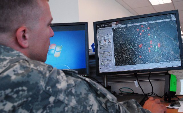
The app provides a real-time schedule of burials, wreath-laying ceremonies and other events at the cemetery. Employees there have been using a similar internal application since March to help manage daily activities at the cemetery.
“You’ll see all of the burials at the cemetery on any given day, and you can zoom to the location,” Miller said.
“It allows us to assign and manage and de-conflict events at the cemetery,” he added.
The web-based application is in sharp contrast to the rooms full of paper records and tattered maps that employees used to keep track of burial locations two years ago, prior to an inspector general report and public outcry over misidentified sites.
“It’s been a good tool for the cemetery,” Miller said of the new application. He said it should be able to prevent any future problems with site identification.
About 25,000 of the 400,000 burial records at the cemetery still need to be checked, he said, which is one reason the app isn’t going live until October.
“It’s not the ‘who is where’ type questions” that need to be resolved, Miller explained. It’s the spelling of Civil War veteran names, dates of birth, dates of death and other such info that needs to be reconciled with Civil War pension slips and so forth, he said.
In the meantime, cemetery employees have been training on the new application and using it in their day-to-day activities.
“Surprisingly it’s gone much smoother than thought,” Miller said of the conversion to automated record-keeping.
The Interment Services Branch has been especially receptive to the new way of doing business, he said
“Once they started using the tools, I think they saw how much value they added to their operations and their work,” Miller said.
The new application shows green icons for burial locations that have been assigned. It shows orange icons for sites that are undergoing maintenance. The map shows what areas or routes should be avoided due to congestion or activities. It even shows where tree pruning is scheduled.
“So it saves time with some of the work they’re doing,” Miller said.
He explained that information which used to be spread across multiple paper records is now accessible at the click of a mouse.
“It adds a lot of transparency and audit ability to our operations,” Miller said.
Miller was cited by Federal Computer Week as a Rising Star in October. He was one of 25 information-technology professionals throughout the federal government who were named as up-and-coming stars.
While he said that he’s honored by the recognition, Miller stresses that he didn’t develop the app on his own.
Arlington National Cemetery partnered with Geographic Information Services, Inc., out of Huntsville, Ala., for the smartphone app. Installation Management Command also has a program office which has helped, Miller said.
The app should be available by Oct. 20 to be downloaded for free from the iTunes Store, from Droid, or from the Army Marketplace, an online site developed by the Chief Information Office or G-6.
More than 4 million visitors per year go to Arlington National Cemetery, Miller said.
“We thought a smart-phone application or web-based application would really allow them to get information about the cemetery without having to interact with anybody, really present information in the palm of their hand.”
For those who don’t have smart phones, kiosks featuring the app will also be available at the cemetery’s visitor’s center and other locations.
The app will provide:
— Directions to gravesites of loved ones
— Daily events like wreath layings and burials (3,000 wreaths laid and 7,000 burials annually)
— Notable historic gravesites (like those of President Kennedy, baseball’s Abner Doubleday, or boxing’s Joe Louis)
“Not only can you find your loved one’s gravesite, but you can see that historical perspective across the cemetery,” Miller said.
The size of the cemetery was the biggest challenge to developing the app, he said. The cemetery has more than 250,000 gravesites, and about 150,000 columbarium niches.
“Collecting 3-inch GPS coordinates for all of the cemetery’s gravesites takes a lot of personnel, a lot of manpower,” Miller said.
Last summer almost an entire company of Soldiers from the 3d U.S. Infantry Regiment (The Old Guard) and other volunteers were put to work photographing each tombstone in the cemetery, both the front and the back. Those photos will be available on the app by clicking on the map.
“We’ve tried to make it as user-friendly as possible,” Miller said of the app.
“Everybody is used to ‘pinch to zoom.’ Everybody is used to double-clicking and getting that information. We wanted to make sure that we replicated the standard features that any iPhone, smartphone, Droid user would have,” he said.
Next year, Miller plans to expand the app to the cemetery at the Armed Forces Retirement Home in Washington, D.C., and continue adding more features to the application for Arlington National Cemetery.


