Chinese Landscape project on Google Earth

kams

New Member
This is a link to some very intresting Gogle Earth photo of what looks a like a Chinese model of a India-China border. This is amazing and look the detailed topography. Wonder what are intentions of Chinese...care to guess???
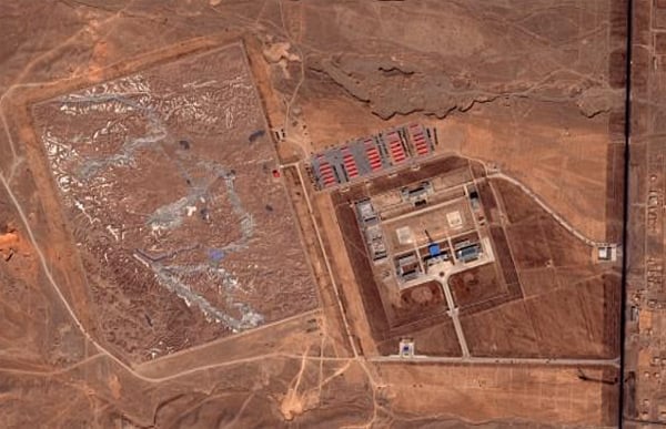

Zooming in for a closer look, we have what appears to be a 900x700m scale model of a mountainous landscape...
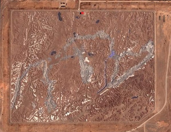

...complete with lakes, valleys and snow-capped peaks:
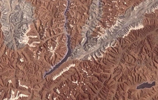

Truly bizarre. Google Earth aficionados can examine the evidence for themselves here (.kmz) while wondering what on Earth, or where on Earth for that matter, this remarkable landscaping project is.

Chinese Landscape
 
Last edited by a moderator:

Pathfinder-X

Tribal Warlord
Verified Defense Pro
kams said:
This is a link to some very intresting Gogle Earth photo of what looks a like a Chinese model of a India-China border. This is amazing and look the detailed topography. Wonder what are intentions of Chinese...care to guess???

Chinese Landscape
While I can only guess that is a detailed model of a mountainous region, the place is at least 2000km away from the India border. Similar geographic layouts can be found in many regions in Asia. How did you arrive at the conclusion this is a model of India-China border?
 

kams

New Member
  • Thread Starter Thread Starter
  • #3
Pathfinder-X said:
While I can only guess that is a detailed model of a mountainous region, the place is at least 2000km away from the India border. Similar geographic layouts can be found in many regions in Asia. How did you arrive at the conclusion this is a model of India-China border?
Sorry, I did not identify the area as India-China Border, some bloggers at the link I provided did. If you go to the second page in the link I provided, they have also put the actual image of the area which is represented by the model. The details match exactly.
 

Grand Danois

Entertainer
kams,

You have found absolute treasure!

Will expand post in a while. Requires some investigation.

;)

Alright.

  • It's a 1:500 scale model.

  • They have to a high degree of likelihood NOT used laserscanning for the data for the model. My guess would be that, depending on when the model was built, they could have used the data from the Shuttle Radar Topography Mission.

    Pre-Defined areas of 3 arc second (90 meter) SRTM "Finished" data in SRTM Format, on DVD, covers the globe between 60 degrees N and 56 degrees S latitude. The SRTM Format is created from the SRTM DTED® Level 1 "Finished" product supplied by NGA.
    This means that they would have 31 sample points per sq meter in model coordinates. More than enough.

  • Alternatively they would have used photogrammetry or airborne/satellite SAR. Hmm.

  • Adding colour to the model is for the benefit of the human eye ie not for agricultural/climatological modelling.

It boils down to if it is not a fake and when it was built.

There is certainly a lot of activity around it.

GD
 
Last edited:

kams

New Member
  • Thread Starter Thread Starter
  • #5
The area modeled is in just south of Aksai Chin. Approximately 40-50% of area modeled is in Indian territory.

Look in these co-ordinates.

105.95N, 38.26E.

How do I paste the image here?
 

Whiskyjack

Honorary Moderator / Defense Professional / Analys
Verified Defense Pro
IMO it may actually pre-date the use of computer modeling, say the 60s-70s, lets face it the Chinese are not short of manpower, a relic from another age.
 

webmaster

Troll Hunter
Staff member
kams said:
How do I paste the image here?
Right Click on the Picture > Properties > Copy the source url and then use the [img ] image-url [/ img] with no spaces to insert pictures in your posts.

Alternatively you can upload the pictures to the server and attach the picture or save it on your desktop and upload that way as an attachment.
 

Grand Danois

Entertainer
Whiskyjack said:
IMO it may actually pre-date the use of computer modeling, say the 60s-70s, lets face it the Chinese are not short of manpower, a relic from another age.
That's why I suggested photogrammetry. ;)
 

kams

New Member
  • Thread Starter Thread Starter
  • #9
Web Master, Grand Danois, Thanks.
My question is why did they build it? It matches the topography of the area very well. Note that its very hilly area...there are some suggestions that this is meant for Helicopter pilots (area Familiarization)..any takers?
 

Whiskyjack

Honorary Moderator / Defense Professional / Analys
Verified Defense Pro
kams said:
Web Master, Grand Danois, Thanks.
My question is why did they build it? It matches the topography of the area very well. Note that its very hilly area...there are some suggestions that this is meant for Helicopter pilots (area Familiarization)..any takers?
Depends when it was built, but if it was built in the 60s-70s then I would say it was for planning ops and war gamming scenarios.
 

kams

New Member
  • Thread Starter Thread Starter
  • #11
Whiskyjack said:
Depends when it was built, but if it was built in the 60s-70s then I would say it was for planning ops and war gamming scenarios.
I don't think its built in 60's or 70's. There is lot of traffic around the structure. Lots of trucks..buildings appear well maintained. I would say that the facility is in use.
 

Whiskyjack

Honorary Moderator / Defense Professional / Analys
Verified Defense Pro
kams said:
I don't think its built in 60's or 70's. There is lot of traffic around the structure. Lots of trucks..buildings appear well maintained. I would say that the facility is in use.
It may have been built in the 60s and 70s and still be in a used base. May be some unit pride involved, etc....The Base commander may use its upkeep as a punishment drill.:D

Of course it may not. But in this day in age where you have computer programmes and simulators, I can't see any other use for it.

Don't read to much into it.
 

Grand Danois

Entertainer
What I find interesting is to find out if it is a hoax or not. If not, then it's purpose.

For starters it wasn't built before 1/1 1999. See link below.

http://www.terraserver.com/

NASA World Wind could perhaps have some more recent LandSat 7 imagery, however it crashes on my computer. :mad:
 
Last edited by a moderator:

Waylander

Defense Professional
Verified Defense Pro
You should not underestimate the usefullness of sandboxes.
It helps you very much to stand in front of a sandbox and look at a terrain instead of sitting in front of a computer screen. It helps you to get a better feeling for the area.
We use sandboxes as well for training (For sure not this big :D )
 

kams

New Member
  • Thread Starter Thread Starter
  • #15
Grand Danois said:
What I find interesting is to find out if it is a hoax or not. If not, then it's purpose.

For starters it wasn't built before 1/1 1999. See link below.

http://www.terraserver.com/

NASA World Wind could perhaps have some more recent LandSat 7 imagery, however it crashes on my computer. :mad:
Thats good one Grand Danois..now If we agree that this is not obselete, (belonging to 60'-70's era)..then question arises ..purpose? This effort must have cost a lot to chinese.
 

Whiskyjack

Honorary Moderator / Defense Professional / Analys
Verified Defense Pro
kams said:
Thats good one Grand Danois..now If we agree that this is not obselete, (belonging to 60'-70's era)..then question arises ..purpose? This effort must have cost a lot to chinese.
According to the news, the Chinese are saying it is a tank training ground.
 

kams

New Member
  • Thread Starter Thread Starter
  • #18
Whiskyjack said:
According to the news, the Chinese are saying it is a tank training ground.
Tank training ground???? That terrain is hardly suitable for any ground vehicle...its all mountains. My bet is on Helicopter..
 

Whiskyjack

Honorary Moderator / Defense Professional / Analys
Verified Defense Pro
Grand Danois said:
I couldn't find it on the net. Where did you hear this? In the local NZ news?

:)
It was in the Sydney Morning Herald (www.smh.com.au).

Trucks are apparently tank transporters.

As the installation is post 1999, I tend to believe it.

You never know I guess:confused: .
 
Top